Day 8
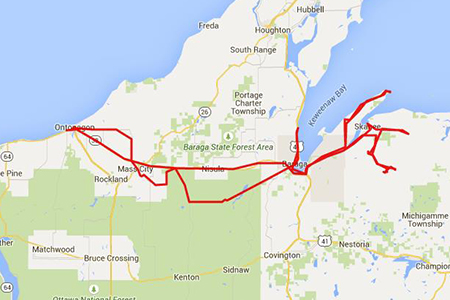
I was going to sleep in the same bed two nights in a row, so I didn't worry about that tonight. Some extra time for exploring, but I really had no idea what I was going to do. Maybe run up to Copper Harbor. Maybe run up to Skanee. Certainly get on some forest service roads.
But first breakfast. Lynn's North Country Cafe is my favorite breakfast spot up there, and they have a really good Friday night fish fry too.

Lynn's North Contry Cafe in Ontonagon
I lingered over breakfast with a map, seeing if a plan would present itself. I listened in on other table's conversations and got all the local gossip. There was this one long-married couple there, and I heard this love poem:
Husband to waitress: Two eggs, sausage and home fries please
Wife: You're having home fries?
Husband: No, I always have American fries.
Wife: You better adjust then.
Husband to waitress: American fries please.
Wife: What would you do without me?
Husband: Eat home fries I guess.
Just taking care of each other, reflexively.
I decided to start the morning in the national forest. I marked a point on the map where a road crossed a river in there, and headed for that.
On the way I ran into a Road Closed sign. Well you know, on a motorcycle a lot of times these roads aren't closed at all. These signs are really soft suggestions to all but the wimpiest of motorcyclists.
In this case I'll give them credit. You could make a fair case that this road was closed. This was a bit more dramatic than routine road construction.
Still ... nope, road was open. I skirted around it and got on my way.


Road closed, almost.
Kinda buried in the middle of a random forest service road was a sign that said "Silver Mountain" with an arrow. At first I ignored it, then I wondered why it was there. So I doubled back and took the side road (which I suppose was a side-road of a side-road).
There was a gated entrance to an old mine, and a long staircase up to the top. The top was pretty much bald with granite rock, and an amazing view. It was a hazy day, and I'll make sure to get back sometime when it's clearer.

Silver Mountain, Ottawa National Forest
The earliest record of mining activity on Silver Mountain was prior to 1847 when miners from the National Company built an adit, or horizontal entrance, and tunneled 150 feet into the base of the mountain in search of silver. The miners were probably drawn to the area by the knowledge that Native Americans found silver particles along the riverbanks. However, the Chippewa had a superstition that the mountain was "haunted" or bad luck. This may have been well founded, for the mine was found abandoned in the fall of 1847. Two well- furnished log cabins and a blacksmith shop were left to rot. Although copper sulphides and silver were reportedly found in the adit, no precious metals were found in the mine and there have been no finds reported there since.
The mountain was later used as a fire lookout tower site built by the Civilian Conservation Corps (CCCs) in the late 1930's. The tower was disassembled in 1971 due to deterioration and the advent of aerial fire detection. The remains of the cement foundation can still be seen atop the mountain.
The mountain rises 1,312 feet above sea level, and overlooks the Silver and Sturgeon River valleys. On a clear day, the view extends into the Copper Country and encompasses parts of Baraga, Houghton, and Ontonagon Counties. From atop Silver Mountain, you can imagine how the once flat sandy plain (an ancient lakebed) was dissected by the action of the Sturgeon River, forming the surrounding ravines. The grooves you see in the bedrock atop Silver Mountain were formed some 10,000 years ago as glacial ice studded with rocks scraped over the bedrock.
To reach the mountain's summit, try either the rustic stairway or the hiking trail located just off of the parking area.


Silver Mountain, Ottawa National Forest
I found my randomly-selected water crossing, and another lookout. There were trail heads down to Sturgeon Falls in a wilderness area. It was more of a hike than I wanted, but one day ...


Sturgeon River Gorge Wilderness overlook
I've not been north of Baraga before, so I figured I'd up go up that side towards Houghton, and probably on up to Copper Harbor. I worked my way up there, stopping at historical sites and signs as I went. But it wasn't a great day to be on the lake. It was hazy so visibility was down, and there was a lot of chilly wind coming off the water. There was not a lot of swimming happening on this 4th of July.
I saw a motorcycle along the way:

Baraga was an early missionary in these parts, converting the natives. A lot of the history focused on him and also native culture. I stopped in at one graveyard that had these above ground "spirit house" structures. I'm not really sure of their significance, I read it is a place to put supplies for the deceased to help him in his trip to the spirit world.


Assinins Cemetery
A pump well in the middle of a cemetery ... I was not about to drink from it.

You are standing where, in 1843, Father Frederic Baraga founded the last of his five Catholic missions seving Native Americans. Today you can follow his footsteps back in time to the nearby cemetery. Among those buried there is Chief Edward Assinins, the first person Baraga baptized locally.
The legendary "Snowshoe Priest" cared about more than the Ojibwas' spiritual life. His knowledge of law helped them avoid forced relocation. Their language is preserved in the dictionary, grammar, and prayer books he wrote and used in the mission school. Later, an orphanage housed both Ojibwa and immigrant children, including some whose parents couldn't support them during hard times.
The Assinins orphanage and school stood in contrast to the government- sanctioned "Indian schools" that forced Native children into white society. Even so, much Iocal knowledge of Native culture, language, and history was lost over time. It is fitting that parishioners of the church Father Baraga founded have restored the school as the Father Baraga Historical Mission and Native Genealogy Center to help the people reclaim their heritage.
The Anishinaabe - The Ojibwa people are known many names ( Ojibwe, Ojibway, Chippewa), but they identify themselves as Anishinaabe, or "original people." Harmony with the land and the cycles of life is central to their culture. Traditionally, they migrated with the seasons along well- worn paths to harvest wild rice, Produce maple sugar, hunt, fish, trap, and trade. One such path, the Kakiweonianing- Ketegitigaaning (L'Anse-Lac Vieux) Trail, begins at the head of Keweenaw Bay. Before European settlement, Ojibwa territory covered a vast Area of the Great Lakes and northern plains. Unlike many Native tribes, the Ojibwa still live on their ancestral lands. though largely on reservations.
I decided to change plans and backtrack, which I hate. But given the weather I decided to work up to Skanee, and maybe possibly see what the roads to Big Bay looked like from this side. I was not looking for trouble today though, I wasn't going to test my limits.
There is no Skanee. I mean, I looked, and there's no downtown or anything. I found a couple nice old houses which probably used to be part of town, but not that much else. I had half a dream of finding a little shoreline village somewhere over there where I could get lunch while looking at the lake. Nothing close to that though.


Skanee, MI
I took to the dirt roads still without a plan, and ran into Big Eric's bridge. There is a state forest campground there that the ATV guys I talked to yesterday were staying at. It was a destination I had planned preparing for this trip that got abandoned when I turned around yesterday, so it was fun to run into it.
The stream ran over bedrock and dug holes into it here-and-there. There are minor little falls. I walked on down there and took of my boots and socks and waded and explored.


Big Eric's bridge over the Huron River
On the walk out there someone had sketched on a log across the path. Apparently they like the place too.


I crossed Big Eric's Bridge and got into the maze of roads and paths out there that support all the ATV and snowmobiles that hang out there. This is really their domain now.
At this point I had not really settled that I was going to attempt to get to Big Bay, but I was going to push in that direction and see what happened.
It's really hard to move in a straight line out there. I wanted to head about due east, but roads kept twisting and turning and there were dead-ends (for me) everywhere. I did the best I could, but basically if I had a firm destination then I would have classified as lost. As it was, it was just that I didn't know where I was.
I got on one road that started to climb, and eventually it winded me to what turns out to be the highest point in Michigan. The top of Mt. Arvon. Who knew?
The roads out there, basically:

ATV trail near Skanee
One of the dead ends:

Not sure why I look so grumpy:


Mt. Arvon
There are picnic tables and a fire pit up there. There is a log for people to sign in. Basically a little camp for ATV'ers that have reached their destination.
I'm not sure why this shrine to Eugene Ott lists him as missing as of 2/23/2008, because it sounds like he died in a local hospital that day: http://www.findagrave.com/cgi-bin/fg.cgi?page=gr&GRid=42583209. That guy enjoyed the outdoors right to the end.

Eugene Ott memorial at Mt. Arvon
I talked to one guy who says the ATV trails have gotten really easy since they started making those big 4-seat "ATV"s. He claimed he saw a BMW Z3 up on Mt Arvon, but he may have been pulling my leg.
There was a log book. The guy had an interesting entry:

Mt. Arvon log book
The view was spectacular.

View from Mt. Arvon
I rode back down from Mt. Arvon and started heading east on snowmobile trail 4. It was getting late, and the road started getting sandy. I figured Mt. Arvon had been a good find and I could call it mission accomplished, so I gave up on Big Bay. So, I turned around and found my way back to Big Eric's bridge, which actually took a bit of effort. Now that I was trying to get somewhere I was a bit lost.
But I found it and made it back to Skanee. I decided, well, lets just head north a bit towards Point Abbaye. I knew nothing about it, I thought maybe there'd be a lighthouse or something up there.
So I rode, and I rode and I rode. It was a lot farther then I expected. And there were lots of houses and private land on the shores. I started to worry that once I got there it might be private property. And the day was getting a bit late, and I had some miles to put on before I got to my bed for the night.
Then I run into these signs for "Hungry Bear Trail". It cracks me up that there are three signs, from large to small. And I can find no reference about "Hungry Bear Trail" online. I don't know what it's about. But north of these signs there were basically no more houses.

Hungry Bear Trail
And the road started getting a big rough.

Pt Abbaye Rd
Eventually the road ended in a small parking lot for a county park. With a sign for the hiking trails.
But, one of the trails had tire tracks on it. And I figured if they can do it then I can do it.

Pointe Abbaye Natural Area
So I went through the gate and down the path

Pointe Abbaye Natural Area
Until I found the end of the road.

Pointe Abbaye on Lake Superior
Point Abbaye is a big chunk of rock jutting out into Superior. This was not the Lake Superior that washes up against the beach on a nice summer day. This was a far more mean Superior. As the lake pushed against the rocks you could just sense the weight of it. The sheer mass of the water.
There were a couple guys out there from Detroit in a truck with one of those above-the-camper-shell tents. Nice guys. But they had come a long way for their solitude, so I left them to it.


Pointe Abbaye on Lake Superior
I would have loved to spend hours up there. But I was already going to get back late. And it wasn't warm, riding after dark was going to be chilly.
So, I headed back south. Riding off the peninsula took a lot less time than getting up there. Funny how that works.
I grabbed gas in L'Anse. There was a big group of bikes clustered together, off all makes. Kind of like that group of bikes I saw up in Canada in White River. A lot like them. Yup, there was the lady on her small cruiser I had chatted with up there. I walked over just as they were pulling out. I said a quick Hi and she gave a wave roared off with her new friends.
South of Baraga everyone was pulled off to the side of the road to watch the 4th of July fireworks. There were fires and families everywhere, bottle rockets and stuff going off. It was a real fun looking scene. Community. I really wished I could have hung out and watched the show, but I had a ways to go yet.

Fourth of July on L'Anse Bay
I got back to the motel around 10PM. I got my money's worth out of the day.
Day 9
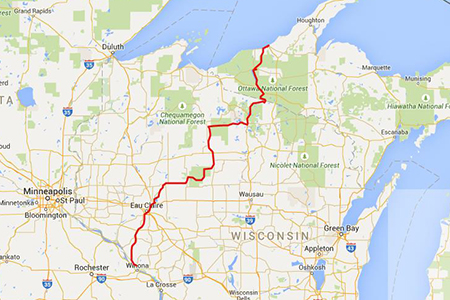
Well, that's about it. Day 9 I rode home and these roads a pretty familiar to me now.
I did start out in the forest,

Ottawa National Forest
And took the back roads into Wisconsin

Heading Home
But I pretty much just put on the miles in a direct route while avoiding major roads, and got home at a reasonable hour.
Can't say the family really acted like they missed me. Odd ...